 ORTWIN v.13.02
Advertisement
Description
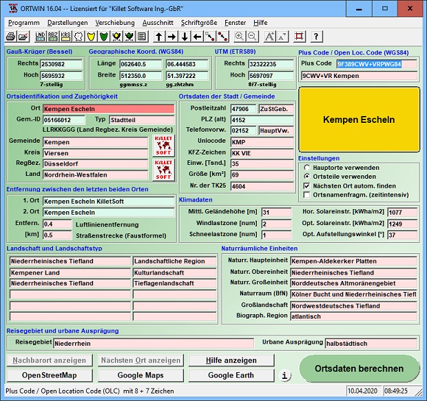
ORTWIN is a program for the state-wide inquiry of the localities, postal codes and telephone selections in Germany. It finds postal zip codes, telephone pre selections, coordinates and ground level elevations. The program determines municipal codes, local center points, car license codes, topographic maps, Unlocodes and much more. It arranges localities hierarchically into the structures federal state, administrative district, rural district,...
Read more
- Rate:
- Release Date:07/19/2017
- License:Shareware
- Category:Database Solutions
- Developer:Killet Software Ing.-GbR
- Downloads:1177
- Size:4.37 Mb
- Price: $120.00
To free download a trial version of ORTWIN, click here
To buy software ORTWIN, click here
To visit developer homepage of ORTWIN, click here
Advertisement
Versions History
| Version | Date Released | Release Notes |
| 13.02 | 19.07.2017 | All databases actualized on 1st. January 2017. Digital signature for secure installation of the program. Determining wind load zones and snow load zones. ORTWIN wins Innovation Award 2016. View of localities in OpenStreetMap, Google Maps, Google Earth. Travel areas and solar irradiation added. |
| 13.00 | 16.01.2017 | Digital signature for secure installation of the program. Determining wind load zones and snow load zones. ORTWIN wins Innovation Award 2016. View of localities in OpenStreetMap, Google Maps, Google Earth. WINDOWS©10 certification after 32Bit / 64Bit test. Travel areas and solar irradiation added. |
| 12.26 | 06.11.2016 | Determining the wind load zones and snow load zones. ORTWIN wins Innovation Award 2016. database actualized on 1st. January 2016. View of localities in OpenStreetMap, Google Maps, Google Earth. WINDOWS©10 certification after 32Bit / 64Bit test. Travel areas and solar irradiation added for all towns. |
| 12.24 | 21.04.2016 | ORTWIN wins Innovation Award 2016. All databases actualized on 1st. January 2016. View of localities in OpenStreetMap, Google Maps, Google Earth. WINDOWS©10 certification after 32Bit / 64Bit intensive test. 8100 new town quarters added. Travel areas and solar irradiation added for all towns. |
| 12.12 | 23.02.2016 | All databases actualized on 1st. January 2015. View of localities in OpenStreetMap, Google Maps, Google Earth. WINDOWS©10 certification after 32Bit / 64Bit intensive test. 8100 new town quarters added. 34600 location coordinates changed with higher accuracy. Travel areas and solar irradiation added. |
| 11.01 | 26.02.2015 | All databases actualized on 1st January 2014. 8100 new town quarters added. 34600 location coordinates with higher accuracy. Freely all over the screen positionable subwindows. Travel areas and solar irradiation added for all towns. Output of window contents in GIF and BMP files. |
| 10.04 | 30.10.2014 | 8100 new town quarters added. 34600 location coordinates changed with higher accuracy. All databases actualized on 1st. January 2014. Freely all over the screen positionable subwindows. Travel areas and solar irradiation added for all towns. Output of window contents in GIF and BMP files. |
Screen Shot
Click on a thumbnail for the larger image.
System Requirements
ORTWIN requires Win2000, WinXP, Win7 x32, Win7 x64, Windows 8, Windows 10, WinServer, WinOther, Windows2000, Windows2003, Windows Server 2012, Windows Tablet PC Edition 2005, Windows Media Center Edition 2005, WinVista, Windows Vista Starter, Windows Vista Home Basic, Windows Vista Home Premium, Windows Vista Business, Windows Vista Enterprise, Windows Vista Ultimate, WinVista x64, Windows Vista Home Basic x64, Windows Vista Home Premium x64, Windows Vista Business x64, Windows Vista Enterprise x64, Windows Vista Ultimate x64.
ORTWIN v.13.02 Copyright
Shareware Junction periodically updates pricing and software information of ORTWIN v.13.02 full version from the publisher using pad file and submit from users. Software piracy is theft, Using crack, password, serial numbers, registration codes, key generators, cd key, hacks is illegal and prevent future development of ORTWIN v.13.02 Edition. Download links are directly from our publisher sites. Links ORTWIN v.13.02 from Bittorrent, mediafire.com, uploadfiles.com, hotfiles.com rapidshare.com, megaupload.com, netload.in, storage.to, depositfiles.com and other files hosting are not allowed. The download file is obtained directly from the publisher, not from any Peer to Peer file sharing applications such as Shareaza, Limewire, Kazaa, Imesh, eDonkey, eMule, Ares, BearShare, Overnet, Morpheus, BitTorrent Azureus and WinMX.
Review This Software
More ORTWIN Software
ORTWIN v.13.02
ORTWIN is a program for the inquiry of localities in Germany. It finds postal zip codes, telephone pre selections, coordinates. It performs perimeter searches and distance calculations. It finds landscapes, natural units, snow- and wind load zones.

ORTWIN Deutsch v.10.00
ORTWIN is a program for the inquiry of localities in Germany. It finds postal zip codes, telephone pre selections, coordinates. It performs perimeter searches and distance calculations. It finds landscapes, natural units, snow- and wind load zones.
ORTWIN English v.10.00
ORTWIN is a program for the inquiry of localities in Germany. It finds postal zip codes, telephone pre selections, coordinates. It performs perimeter searches and distance calculations. It finds landscapes, natural units, snow- and wind load zones.
Other products of this developer Killet Software Ing.-GbR

DRAGSENS v.4.01
DRAGSENS Geo Software is used for the exact posi... estimation of the position of a dragged sensor.

Geodata Germany v.22.03
The database contain geodata of the Federal Repu...capes, climatic zones for proximity searches ec.

Geodata International v.10.05
Geodata International - World-wide database of c...ximity search, navigation, distance calculation.

GeoDLL v.18.24
GeoDLL is a Geodetic Development Kit / Geodetic ...rt, NTv2, HARN, INSPIRE, EPSG, DEM and much more

Graphics4VO DLL v.11.04
Graphics4VO is the graphics interface for the pr... the display, printer, plotter, file and memory.

SEVENPAR v.8.01
SEVENPAR calculaties exact parameter sets for th...eference systems for coordinate transformations.

TOPOWIN v.16.00
TOPOWIN is a state-wide register of the German t...ms. It also is a topographic information system.

TRANSDAT v.20.37
TRANSDAT Coordinate Conversion supports thousand...le systems and much more with highest accuracy.